Nowadays, farm mapping doesn’t have any reason to be a daunting task. Farmers can now obtain a highly precise map of their farm, more quickly than one would think and at a very low cost. What does one need for this? A GPS!
The project Sustainable Amazonian Landscapes (SAL) designed and tested a methodology for the mapping of farms and the collection of data on land uses at the scale of 1:10,000. This process consists of a mixed method employing both participatory mapping and topographical surveying using low cost technologies.
Projects have greater success if they include local participation in their design and execution
This methodology was applied with the active participation of agricultural producers and the support of the different project partners.
So far, the project SAL has carried out mapping, using the methodology described, of more than 40 farms in Caqueta, Colombia and Yurimaguas, Peru. In addition, after carrying out the surveying, soils samples are taken to use for the physical-chemical analysis of land use and the evaluation of macro-fauna as biological indicators.
The maps are something more than just papers. They are narratives, conversations, lives and the living songs of the place, and they are inseparable from the political and cultural context in which they are used.
Warren, 2004
There are 45 farms mapped to date.
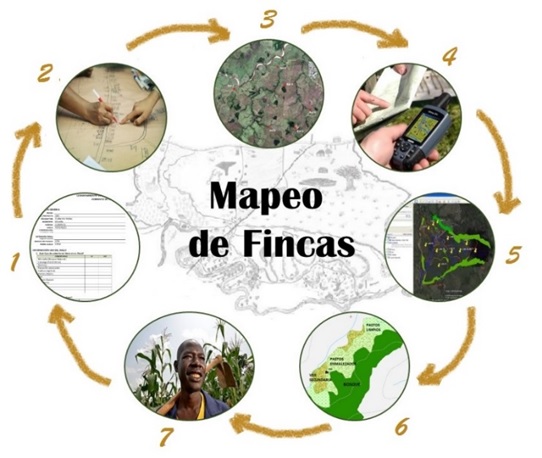
Farm mapping – The methodology in 7 simple steps:

1. Format registry with key information
2. Participatory mapping
- First comes the sketching of the property and the identification of neighboring properties, rivers, paths, roadways, water sources, infrastructure, and soil uses, in an activity where ideally the whole family participates.
3. Satellite imagery
- With aid from Google Earth or high resolution images and the previously created sketch, we then identify the trajectory and the reference points (vertices of the farm) in order to facilitate creating the tour of the property.
4. GPS Points
- We take geo-referenced points of the vertices of the property previously identified. During the trip we also carry out surveying of land covers or of soil uses through GPS-Tracks and photographs.
5. Visualization of the property
- From the GPS points taken and the construction of the territory’s polygon, supported by satellite terrain images and knowledge of the farmer.
6. Design of final map
- Made with the help of GIS tools and thematic information of rivers, roadways and the territories of other properties.
7. Happy farmer!
- After obtaining the geo-referenced map of their property within a day.
The farm map is very valuable for the farmers: in addition to providing precise and up to date information of the area of their farm and of the distribution and proportion of its soil uses, it is also a very useful tool for land management and planning.
Visit the image galleries:
- Surveying of boundaries and land covers in Yurimaguas
- Surveying of boundaries and land covers in Caqueta
Thank you to all of the project partners who have allowed for the development of these activities in the project SAL.


